GeoBox-R1: Curriculum-Guided SFT and Geometric RL for Unified Box-Level Remote Sensing Visual Grounding

Chenxi Lan*, Yuchen Wu*, Minghang Zhou, Tianyu Li, Zhihao Qiu, Guoqing Wang†
University of Electronic Science and Technology of China
*Equal contribution   †Corresponding author
Under review at AAAI 2027

GeoBox-R1 localizes objects from natural-language expressions in aerial imagery, returning either a horizontal or an oriented box under one unified interface.

58.78
HBB Acc@0.5 (macro avg.)
47.32
OBB Acc@0.5 (macro avg.)
4B
parameters, beats 7B–8B
10
benchmarks (7 HBB + 3 OBB)

Abstract

Remote sensing visual grounding (RSVG) aims to localize the object referred to by a natural-language expression in aerial or satellite imagery. Recent multimodal large language models (MLLMs) make unified box-level grounding feasible, but general-purpose models do not reliably produce oriented bounding boxes (OBBs) and often fall back to horizontal bounding box (HBB) outputs. Jointly training a single model for HBB and OBB prediction is also challenging, because the two tasks require different levels of semantic grounding and geometric precision.

We propose GeoBox-R1, a two-stage training paradigm for unified box-level RSVG. It first performs curriculum-guided supervised fine-tuning, ordering training data from HBB grounding to OBB grounding and finally to HBB-to-OBB Chain-of-Thought supervision. It then applies geometric reinforcement learning via Group Reward-Decoupled Normalization Policy Optimization (GDPO), using two rule-based geometric rewards — Rotated IoU and adaptive Wasserstein distance — to refine OBB prediction.

Across 7 HBB and 3 OBB benchmarks, GeoBox-R1 achieves the best macro averages on all three metrics for both tasks. With only 4B parameters, it surpasses state-of-the-art 7B–8B models, leading by 3.68/4.89/2.61 points on HBB and 5.36/7.74/2.89 points on OBB, with the largest gains at the stricter Acc@0.7 threshold.
Motivation

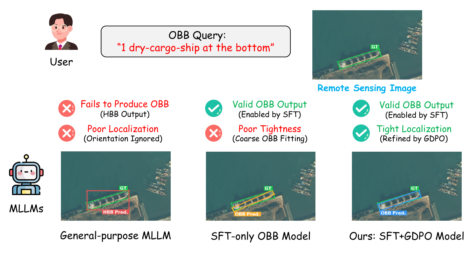
Under an explicit OBB prompt a general-purpose MLLM returns a horizontal box, while GeoBox-R1 returns a correctly oriented box.

Given the query “1 dry-cargo-ship at the bottom” the ground truth is an oriented box around the ship. A general-purpose MLLM fails to produce an OBB at all and returns a horizontal box that ignores orientation. SFT makes valid OBB outputs possible, but the SFT-only model still fits the target loosely. Geometric RL then tightens it: ours (SFT + GDPO) aligns closely with the ground truth.

Method

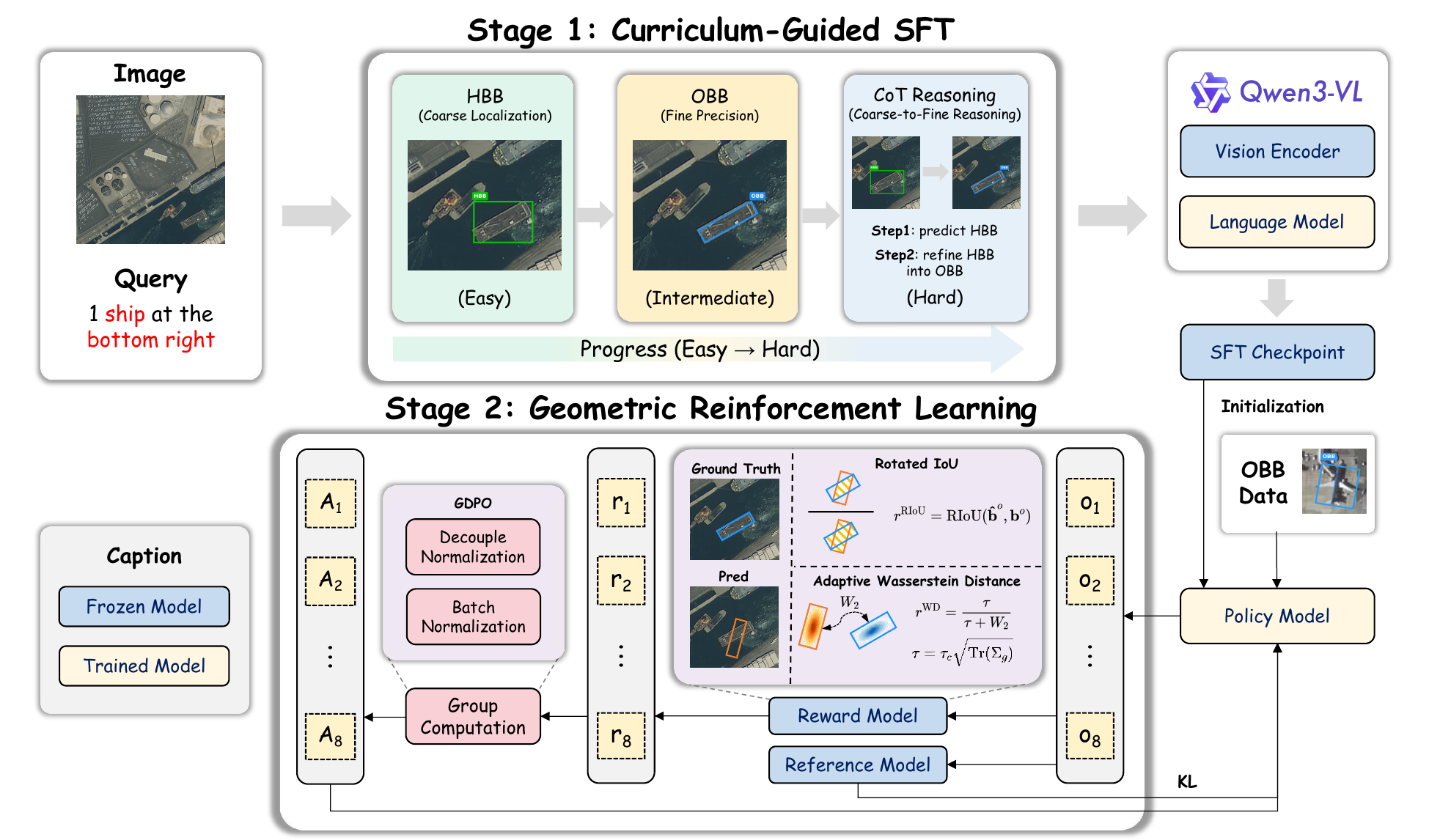
Two-stage GeoBox-R1 pipeline: curriculum-guided SFT followed by GDPO geometric reinforcement learning.

Stage 1 establishes unified box-level grounding through a curriculum. Stage 2 refines oriented localization with GDPO.

Stage 1 — Curriculum-guided SFT

Training data is presented easy-to-hard rather than shuffled:

  1. HBB grounding establishes coarse semantic localization.
  2. OBB grounding introduces orientation and aspect-ratio sensitivity.
  3. HBB-to-OBB CoT supervises the reasoning that refines a coarse horizontal box into a tight oriented box.
$$\mathcal{D}_{\mathrm{SFT}}=\mathcal{D}_{\mathrm{HBB}}\oplus\mathcal{D}_{\mathrm{OBB}}\oplus\mathcal{D}_{\mathrm{CoT}}$$

Concatenation, not shuffling — the curriculum lives in the data order, under one ordinary token-level objective.

161,692 samples: 32,638 HBB, 96,791 OBB, 32,263 CoT.

Stage 2 — Geometric RL with GDPO

Two rule-based geometric rewards, no learned reward model:

  • Rotated IoU gives direct overlap supervision for oriented boxes.
  • Adaptive Wasserstein distance stays informative when RIoU saturates near zero, common for small or elongated targets.
$$r^{\mathrm{WD}}=\frac{\tau}{\tau+W_2},\qquad\tau=\tau_c\sqrt{\mathrm{Tr}(\boldsymbol{\Sigma}_g)}$$

Scaling $\tau$ with target size keeps reward sensitivity comparable across scales; a fixed $\tau$ systematically under-rewards large objects.

Equal weights ($\lambda_k=0.5$ each), on a 20% OBB subset (19,357 of 96,791).

Reward-decoupled advantage

$$\tilde{A}_i=\sum_{k\in\{\mathrm{RIoU},\mathrm{WD}\}}\lambda_k\,\frac{r_i^{(k)}-\bar{r}^{(k)}}{\sigma^{(k)}+\varepsilon}\qquad\qquad\hat{A}_i=\frac{\tilde{A}_i-\mu_{\mathcal{B}}(\tilde{A})}{\sigma_{\mathcal{B}}(\tilde{A})+\varepsilon}$$

Each reward channel is normalized within its own group of $G$ completions before the two are combined, so the channel with the larger numeric range cannot dominate. A second normalization over the mini-batch $\mathcal{B}$ then stabilizes the advantage scale under both geometric objectives.

HBB grounding — 7 evaluation sets

Switch metric with the buttons. Red is best, blue underline is second best, across the whole table.

ModelParams DIOR-RSVG-Test DIOR-RSVG-Val RSVG-Test RSVG-Val GeoChat* VRSBench* AVVG Avg.
General-Purpose MLLMs
InternVL32B 15.01 13.60 0.24 0.33 11.09 5.51 2.15 6.85
LLaVA-OV-1.54B 18.39 16.68 1.79 1.25 11.92 7.98 1.69 8.53
LLaVA-OV-1.58B 23.59 22.63 1.14 1.50 18.42 13.39 1.65 11.76
InternVL38B 29.94 27.44 1.14 1.58 24.79 19.45 6.12 15.78
Qwen2.5-VL3B 37.52 37.90 13.69 14.32 36.07 36.74 18.83 27.87
Qwen2.5-VL7B 40.31 38.59 14.83 16.74 41.84 41.51 21.91 30.82
Qwen3-VL4B 51.91 51.38 33.17 32.89 49.17 51.42 23.93 42.01
Qwen3-VL8B 54.14 53.68 33.82 34.80 50.73 53.55 25.22 43.70
Remote Sensing MLLMs
LHRS-Bot7B 13.15 12.56 0.65 0.33 2.16 1.21 0.15 4.32
LHRS-Bot-Nova8B 31.31 29.75 2.12 1.75 26.13 12.54 1.04 14.95
GeoChat7B 31.04 29.16 2.44 4.16 36.69 14.38 0.31 16.88
Supervised Fine-Tuning on refGeo
GeoChat (SFT)7B 45.42 43.37 2.20 3.41 35.81 27.56 0.78 22.65
InternVL3 (SFT)2B 57.15 56.12 8.56 10.32 40.15 36.29 9.58 31.17
LLaVA-OV-1.5 (SFT)4B 61.49 59.73 20.70 22.81 45.49 37.60 10.00 36.83
Qwen2.5-VL (SFT)3B 68.09 66.72 39.85 34.55 52.44 57.26 27.11 49.43
GeoGround7B 77.70 77.13 26.65 27.81 69.76 65.76 21.60 52.35
InternVL3 (SFT)8B 74.83 75.06 46.05 44.05 59.23 58.05 28.41 55.10
GeoBox-R1 (SFT)4B 74.91 74.21 48.57 46.29 61.39 64.45 30.33 57.17
GeoBox-R1 (SFT + GDPO)4B 76.61 75.11 51.26 48.38 61.13 66.84 32.14 58.78
ModelParams DIOR-RSVG-Test DIOR-RSVG-Val RSVG-Test RSVG-Val GeoChat* VRSBench* AVVG Avg.
General-Purpose MLLMs
InternVL32B 6.95 6.61 0.00 0.08 5.09 1.67 0.42 2.98
LLaVA-OV-1.54B 4.10 3.72 0.24 0.08 2.03 1.18 0.07 1.63
LLaVA-OV-1.58B 6.36 6.14 0.16 0.25 3.33 2.55 0.10 2.70
InternVL38B 16.50 14.82 0.41 0.33 10.11 6.89 2.87 7.42
Qwen2.5-VL3B 25.98 26.72 8.15 8.91 19.68 19.10 12.56 17.30
Qwen2.5-VL7B 26.77 25.13 7.91 10.16 21.65 21.18 15.07 18.27
Qwen3-VL4B 38.16 37.05 20.05 19.57 28.29 28.80 18.99 27.27
Qwen3-VL8B 41.50 40.50 20.13 19.98 29.23 29.80 18.55 28.53
Remote Sensing MLLMs
LHRS-Bot7B 3.02 3.24 0.08 0.08 0.30 0.22 0.02 0.99
LHRS-Bot-Nova8B 12.36 11.66 0.24 0.17 8.68 2.67 0.00 5.11
GeoChat7B 8.72 8.18 0.24 0.42 13.57 3.16 0.00 4.90
Supervised Fine-Tuning on refGeo
GeoChat (SFT)7B 21.40 20.42 0.41 0.75 14.44 8.45 0.10 9.42
InternVL3 (SFT)2B 38.17 36.73 2.12 1.92 17.07 14.94 3.71 16.38
LLaVA-OV-1.5 (SFT)4B 40.97 39.63 5.05 6.24 16.50 14.51 2.41 17.90
Qwen2.5-VL (SFT)3B 53.42 53.23 20.54 17.32 29.47 34.31 19.73 32.57
GeoGround7B 64.98 63.00 10.02 9.08 50.66 39.05 8.37 35.02
InternVL3 (SFT)8B 62.76 61.57 25.51 25.81 32.03 33.70 19.91 37.33
GeoBox-R1 (SFT)4B 62.46 62.23 29.42 28.73 35.13 39.58 24.74 40.33
GeoBox-R1 (SFT + GDPO)4B 64.78 63.13 32.60 31.97 35.49 41.16 26.39 42.22
ModelParams DIOR-RSVG-Test DIOR-RSVG-Val RSVG-Test RSVG-Val GeoChat* VRSBench* AVVG Avg.
General-Purpose MLLMs
InternVL32B 20.74 19.52 1.73 2.16 14.93 11.08 3.58 10.53
LLaVA-OV-1.54B 24.63 23.88 4.88 5.26 20.34 16.70 5.30 14.43
LLaVA-OV-1.58B 27.58 26.91 4.08 3.86 24.19 21.44 4.02 16.01
InternVL38B 30.56 29.47 3.99 5.14 26.38 23.67 6.94 18.02
Qwen2.5-VL3B 37.47 37.29 14.62 15.48 34.83 35.25 15.36 27.18
Qwen2.5-VL7B 39.29 38.09 15.50 16.97 38.51 38.76 17.78 29.27
Qwen3-VL4B 48.21 47.58 30.72 30.45 43.37 45.21 19.79 37.90
Qwen3-VL8B 50.81 49.63 31.81 30.78 44.37 46.72 20.21 39.19
Remote Sensing MLLMs
LHRS-Bot7B 18.37 18.22 1.68 1.04 7.24 6.14 1.31 7.71
LHRS-Bot-Nova8B 30.99 29.89 4.80 4.12 26.92 19.55 3.51 17.11
GeoChat7B 32.52 31.54 7.99 9.74 36.17 23.66 1.86 20.50
Supervised Fine-Tuning on refGeo
GeoChat (SFT)7B 41.20 39.93 4.93 6.10 35.35 31.69 3.07 23.18
InternVL3 (SFT)2B 50.18 49.41 12.67 14.91 37.34 36.52 10.70 30.25
LLaVA-OV-1.5 (SFT)4B 53.04 51.90 24.28 24.37 40.63 38.13 11.64 34.86
Qwen2.5-VL (SFT)3B 59.85 59.09 34.68 30.74 45.66 49.19 22.36 43.08
GeoGround7B 68.28 67.54 28.15 27.08 57.97 56.27 22.28 46.80
InternVL3 (SFT)8B 65.99 65.71 40.08 39.19 48.16 50.57 24.74 47.78
GeoBox-R1 (SFT)4B 65.99 65.55 40.51 39.75 50.34 54.28 25.32 48.82
GeoBox-R1 (SFT + GDPO)4B 67.50 66.57 42.99 42.00 51.25 55.74 26.68 50.39

* denotes a modified test split. GeoGround leads on DIOR-RSVG and GeoChat*, GeoBox-R1 leads on RSVG and AVVG — the macro-average gain reflects complementary per-dataset behavior rather than uniform dominance.

OBB grounding — 3 evaluation sets

ModelParams GeoChat* VRSBench* AVVG Avg.
GeoChat7B 31.73 11.76 0.10 14.53
InternVL3 (SFT)2B 24.57 19.82 0.98 15.12
GeoChat (SFT)7B 28.95 21.78 0.26 17.00
LLaVA-OV-1.5 (SFT)4B 33.23 23.87 2.69 19.93
Qwen2.5-VL (SFT)3B 49.36 41.67 16.13 35.72
InternVL3 (SFT)8B 49.79 42.01 15.43 35.74
GeoGround7B 58.72 53.26 13.89 41.96
GeoBox-R1 (SFT)4B 55.96 51.14 22.23 43.11
GeoBox-R1 (SFT + GDPO)4B 60.56 56.61 24.79 47.32
ModelParams GeoChat* VRSBench* AVVG Avg.
GeoChat7B 8.27 2.04 0.00 3.43
InternVL3 (SFT)2B 5.26 7.48 0.15 4.30
GeoChat (SFT)7B 11.07 5.80 0.03 5.64
LLaVA-OV-1.5 (SFT)4B 9.76 8.71 0.59 6.35
Qwen2.5-VL (SFT)3B 22.65 21.55 8.63 17.61
InternVL3 (SFT)8B 23.10 20.65 7.40 17.05
GeoGround7B 25.49 29.82 4.10 19.81
GeoBox-R1 (SFT)4B 30.45 27.69 15.07 24.40
GeoBox-R1 (SFT + GDPO)4B 35.19 30.55 16.89 27.55
ModelParams GeoChat* VRSBench* AVVG Avg.
GeoChat7B 31.25 21.26 1.08 17.87
InternVL3 (SFT)2B 27.28 24.84 4.35 18.82
GeoChat (SFT)7B 30.14 27.70 1.97 19.94
LLaVA-OV-1.5 (SFT)4B 33.18 28.54 6.14 22.62
Qwen2.5-VL (SFT)3B 40.46 39.98 15.12 31.86
InternVL3 (SFT)8B 41.66 40.68 15.39 32.58
GeoGround7B 46.89 48.35 15.64 36.96
GeoBox-R1 (SFT)4B 45.45 45.91 19.20 36.85
GeoBox-R1 (SFT + GDPO)4B 48.92 49.43 21.18 39.85

GDPO lifts the SFT checkpoint from 43.11 to 47.32 average Acc@0.5, leading GeoGround by 5.36 / 7.74 / 2.89 points across the three metrics.

Qualitative comparisons

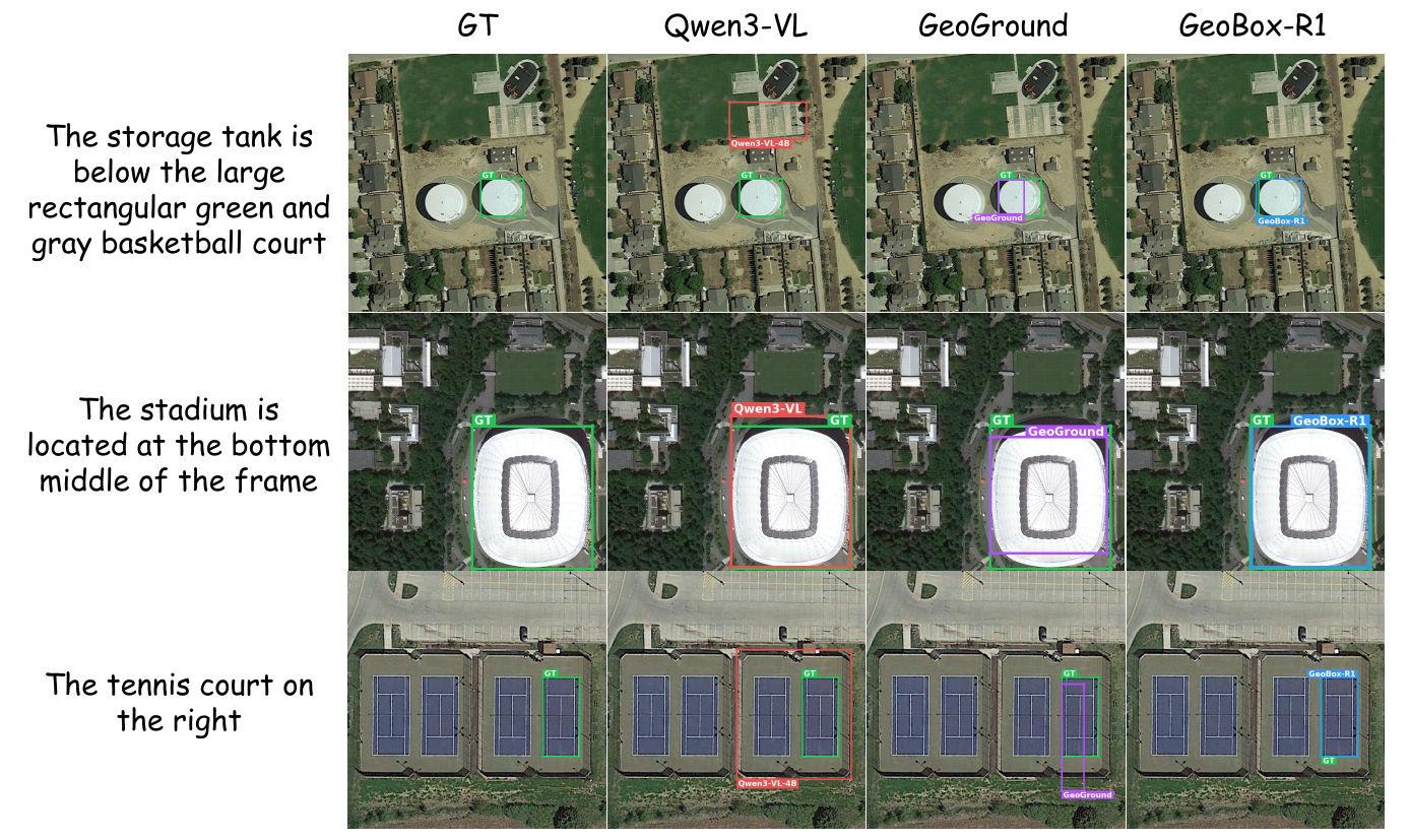
HBB grounding. Qwen3-VL selects a coarse salient region and GeoGround drifts toward nearby structures, while GeoBox-R1 resolves the storage tank's relation to the reference court, captures the stadium extent tightly, and follows the rightward cue for the tennis court. Green: ground truth; red: Qwen3-VL; purple: GeoGround; blue: GeoBox-R1.

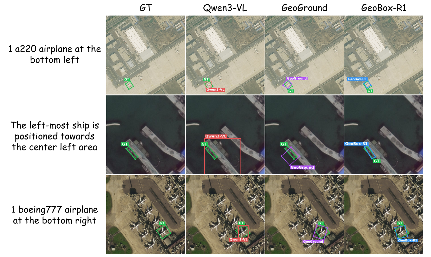
OBB grounding. Prompted for oriented boxes, Qwen3-VL falls back to horizontal boxes and GeoGround shows corner or angle offsets, while GeoBox-R1 aligns tightly with elongated ships and airplanes where orientation and aspect ratio are critical.

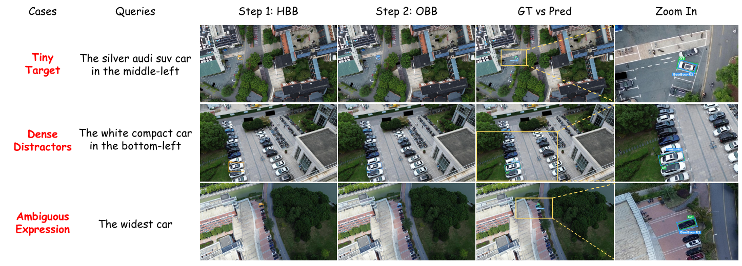
HBB-to-OBB Chain-of-Thought. Three challenging car-grounding queries: a tiny target, dense distractors, and an ambiguous expression. Yellow marks the coarse HBB cue and zoom region; blue is the refined OBB; green is ground truth.

Data

Training data is built on refGeo, aggregating five remote sensing grounding sources.

SFT mixture

Source HBB OBB CoT Total
DIOR-RSVG27,1330027,133
RSVG5,505005,505
GeoChat047,91215,97163,883
VRSBench029,0179,67238,689
AVVG019,8626,62026,482
Total32,63896,79132,263161,692

OBB-only RL subset

Source Full OBB pool 20% subset
GeoChat47,9129,582
VRSBench29,0175,803
AVVG19,8623,972
Total96,79119,357

The 20% subset used for GDPO.

Implementation

GeoBox-R1 is instantiated on Qwen3-VL-4B-Instruct; both stages use ms-swift.

BibTeX

@misc{geoboxr1,
  title  = {GeoBox-R1: Curriculum-Guided SFT and Geometric RL for
            Unified Box-Level Remote Sensing Visual Grounding},
  author = {Lan, Chenxi and Wu, Yuchen and Zhou, Minghang and
            Li, Tianyu and Qiu, Zhihao and Wang, Guoqing},
  year   = {2026},
  url    = {https://yuchenwu73.github.io/geobox-r1/},
  note   = {Preprint}
}